
Which ZIP Code Serves Brambleton
Brambleton has one primary postal area confirmed in the official materials: 20148. The postal city line is Ashburn, VA, even though Brambleton is the local community name. Loudoun identifies Brambleton as a Census-Designated Place, not an incorporated town, so the postal line, the CDP, and the county jurisdiction each describe a different part of the same address. No second ZIP serving the Brambleton CDP was located in the reviewed official sources. An address near an edge or with a special delivery arrangement still needs an exact USPS check.
| ZIP | Areas covered | Postal line | Record-search note |
|---|---|---|---|
| 20148 | Brambleton CDP and a broader postal area including Broadlands, Moorefield, Arcola, Waxpool, and Southbridge | Ashburn, VA | Use the CDP, parcel, road, or subdivision layer to isolate Brambleton from the wider mailing area. |
The county ZIP map and a WebLogis parcel sample support that result. They do not make every 20148 address a Brambleton address. For a road-level record path after the postal area has been narrowed, use the Brambleton Street Directory and confirm the parcel rather than relying on a ZIP alone.
Brambleton ZIP Geography Is Broader
Loudoun’s mapping materials describe ZIP polygons as USPS-provided postal boundaries that are generalized for mapping and maintained as needed. A polygon can help orient a search, but it is not a legal boundary and does not define a government jurisdiction. The broader 20148 area reaches beyond Brambleton into several nearby places, so a countywide postal-area result needs another geographic filter before it can describe the CDP.
That distinction matters most when records use different labels. A parcel can carry an Ashburn postal line, sit inside the Brambleton CDP layer, and be administered by Loudoun County. None of those labels establishes a person’s present connection to the parcel. The strongest match uses the full address, the PIN, and the relevant map layer, with the record date preserved.
Verify a Brambleton ZIP Code
The USPS ZIP Lookup is the delivery-format check. Its By Address form requires a street address, city, and state. Company, apartment or suite detail, and a ZIP entry are optional. Use Ashburn for the postal city field and Virginia for the state; keep Brambleton as the community label when comparing the result to county geography. A unit number can make the result more precise.
| USPS field | How it is used |
|---|---|
| Street Address | Required delivery address line. |
| Apt/Suite/Other | Optional unit detail that can narrow a match. |
| City and State | Required postal locality fields; use Ashburn and Virginia for this area. |
| ZIP Code | Optional refinement or verification field. |
USPS cautions that a returned address does not confirm a person or company there. It normalizes mail delivery information, not residency, ownership, or business activity. When a result varies from an old address form, retain the exact result and then check the county’s current address and parcel data.
Search Brambleton by ZIP
A postal-area search works best as a short verification sequence rather than as a roster. The assessor’s address screen did not expose a verified ZIP filter during the inspected maintenance state. Start with the address or PIN, then use the map and USPS result to compare the postal and geographic labels.
- Enter the exact street and unit in USPS, and save the returned city and ZIP string.
- Search the Loudoun assessment database by number, street, and unit to obtain the property record and PIN.
- Open WebLogis, locate the address or PIN, and turn on ZIP and CDP or planning layers.
- Use subdivision, road, or parcel boundaries to distinguish a Brambleton parcel from the wider 20148 postal area.
For a document or permit question, use the PIN and date after this comparison. A postal label is a useful filter, but the parcel identifier is the stronger bridge between county systems.
Brambleton Map Layers and Parcels
WebLogis places the postal layer beside the records geography that a mailing result lacks. Its public controls support address, PIN, tax-map, and map-click searches, and its layers include ZIP Codes, address points, road centerlines, parcel boundaries, subdivisions, election districts, planning layers, CDPs, schools, and imagery. The map identifies geography; it is not a deed-image repository and does not establish a current resident.
The county WebLogis parcel result shows the kind of bridge a result can provide between postal and development terms.
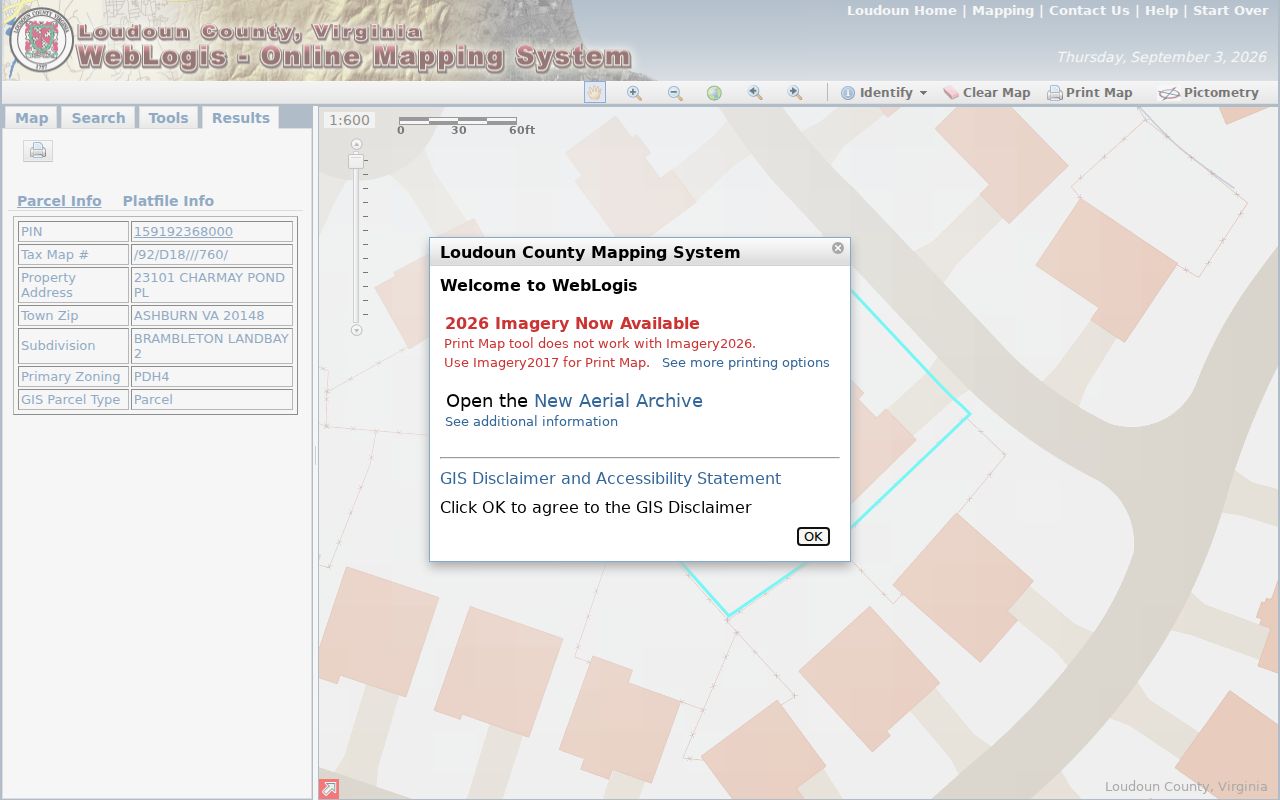
That sample displays Ashburn VA 20148 and the subdivision name BRAMBLETON LANDBAY 2. Landbay, subdivision, section, and lot fields can narrow a broad postal result when a street name alone is too common.
Note: A WebLogis result can show the parcel, ZIP, and adjacent map context, but it should not be treated as evidence of a household’s current occupants.
Brambleton Permit ZIP Fields
Loudoun’s residential permit layer supplies a ZIP-related field called ZI_ZIP, along with PIN, issue month and year, street address, subdivision or project, election district, planning subarea, town, and zoning fields. Technical users can group permit data by its ZIP field, but that output dates construction activity rather than a person’s connection to an address. The historical residential permit layer begins in 2010 and runs through the prior year.
Issued building-permit reports reach back to 2015, while the county’s LandMARC route provides the current permit and land-development path. Use an issue or final date to place work on a timeline. It is not a move-in date, and it does not turn a postal area into a resident list.
Brambleton ZIP Boundaries Aren't Legal
ZIP geography answers where mail is routed. The Brambleton CDP layer answers a Census place question, while Loudoun County is the public-record jurisdiction. Those labels often appear together, but they are not interchangeable. A 20148-wide search may include addresses beyond Brambleton, and an Ashburn postal line does not erase the local community name.
For a county record request, describe the property by address, PIN, or document reference and identify the relevant time range. Virginia Freedom of Information Act requests should be reasonably specific. The county must respond within five working days with records, a lawful withholding explanation, a no-record response, or a statement that more time is needed under the statute.
Brambleton Postal Terms Defined
Postal terms are easy to confuse with parcel or community labels. These definitions keep an address verification focused on what the postal system actually returns.
- ZIP
- A postal delivery area. It can cross community and government boundaries.
- ZIP+4
- An added four-digit delivery segment used to refine routing beyond the five-digit ZIP.
- PO Box ZIP
- A ZIP assigned for post-office boxes, which may differ from a street-delivery ZIP.
- Carrier route
- A delivery route within a postal area, not a legal parcel or residency boundary.
USPS also offers city-and-state and reverse ZIP modes. A postal-city search can return more than one ZIP, which is why the Brambleton-specific conclusion should begin with the exact address rather than a broad Ashburn query. Save the returned form of the address with the date of the search.
Brambleton ZIP Evidence and Limits
Brambleton’s rapid growth helps explain why postal and modern parcel tools are central to current searches. Census QuickFacts reports 23,486 people in the Brambleton CDP in 2020, compared with 9,845 in 2010. Those are CDP-wide statistics, not characteristics of an individual parcel. The planned community began receiving homes in 2001, so a current subdivision record may be recent even when the parent tract has a much older Loudoun deed trail.
Use 20148 to frame a postal-area question, then document the narrower location with the precise address, PIN, subdivision, and CDP layer. That produces a clearer record trail and avoids turning a shared mailing area into an overbroad claim about Brambleton.
Brambleton ZIP History Needs Parcels
USPS verifies current delivery formatting, not the history of a subdivision address. Brambleton began receiving homes in 2001, but the Loudoun land and court record collection reaches to 1757. For an older-address question, begin with today’s parcel identifier, landbay, plat, and legal description. Follow the recorded deed trail toward the parent tract, then use maps, census material, newspapers, and library records to understand the earlier place name. A current 20148 result is useful at the beginning of that work, but it cannot reconstruct the pre-development address on its own.
Thomas Balch Library in Leesburg is the local historical route for Loudoun maps, deeds and wills, census microfilm, newspapers, cemetery material, and house files. Its Sanborn maps explain historical town streets and building patterns, but they do not map modern Brambleton. For a ZIP discrepancy or current address-point question, return to Loudoun Mapping & GIS with the address, PIN, map evidence, and requested correction. Keep a postal change, a parcel change, and a documented occupancy claim as separate facts. That careful record trail also makes it easier to revisit a result if the USPS city line or county map layer later changes.